Saturday, March 31, 2018
March Monthly Weather Update
Saturday, March 24, 2018
Spring Melt begins
Check out this coming week's weather! Spring melt will begin in earnest with nighttime temps rising above freezing more often than not. Of course this transition will also bring us some freezing rain as well.
Friday, March 23, 2018
Frost Heave Season
Saturday, March 17, 2018
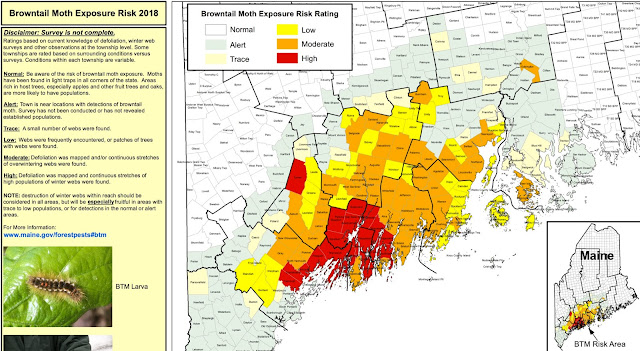
Browntail Moth removal should start now
 |
| And...we live in the RED ZONE! |
CLICK HERE for the Risk Map as of March 12, 2018.
Check out this Maine Dept. of Agriculture, Conservation, and Forestry video on starting now to remove the browntail moth webs from trees on your property. Here is an article from the Maine Center For Disease Control and Prevention on the browntail moth.
Wednesday, March 14, 2018
SNOW DAY # 9
SNOW TOTAL THUS FAR THIS WINTER: 103.5".
Storm Total = 14.5" (We had 31.5" snow from two storms in 6 days)
10 am - one more inch of snow.
Snow table cleared at 7:40 am
7:30 am - 6 more inches of snow. = 13.5" total thus far.
It's still snowing, and we should get a few more inches before the storm ends.
Storm Total = 14.5" (We had 31.5" snow from two storms in 6 days)
10 am - one more inch of snow.
Snow table cleared at 7:40 am
7:30 am - 6 more inches of snow. = 13.5" total thus far.
It's still snowing, and we should get a few more inches before the storm ends.
 |
| Snowy backyard |
 |
| The snowy house |
 |
| The snow is ganging up on us. |
 |
| The snow covered wood that will warm us next year! |
Tuesday, March 13, 2018
Winter Storm Skylar - Blizzard warning for 14 hours! + SNOW DAY # 8
9:30pm update: added a second inch = Total 7.5" thus far. Snowing hard.
8pm update: 1" new snow on table.
-----------------------------------------------------------------------------------
5pm update: 5.5" snow. Not much snow...Mostly wind. Snow table cleared.
4pm update: 5" snow.
This is going to be one slow moving storm! The snow will last from 9am today (Tuesday) through around 8am Thursday! Woweeeee;-) Ummm... we might end up with 2 snow days out of this storm!
...BLIZZARD WARNING IN EFFECT FROM 11 AM THIS MORNING TO 2 AM EDT WEDNESDAY... * WHAT...Blizzard conditions expected. Travel will be very dangerous to impossible, especially this afternoon and evening. Tree branches could fall as well. Total snow accumulations of 14 to 18 inches are expected, with locally higher amounts. * WHERE...The New Hampshire Seacoast. In Maine, Coastal York, Coastal Cumberland, and Sagadahoc Counties. * WHEN...From 11 AM this morning to 2 AM EDT Wednesday. * ADDITIONAL DETAILS...Winds gusting as high as 50 mph will cause whiteout conditions in blowing snow. Significant drifting of the snow is likely. PRECAUTIONARY/PREPAREDNESS ACTIONS... A Blizzard Warning means severe winter weather conditions are expected or occurring. Falling and blowing snow with strong winds and poor visibilities are likely.
Monday, March 12, 2018
Storm Map updated probable totals
Well, it looks like we might just get over a foot of snow from this storm! Check out the updated storm totals;-)
Sunday, March 11, 2018
Next Nor'easter developing
Well...we might just get pummeled again on Tuesday! But, I am hazarding a guess that we'll have school if the storm rolls through late enough on Tuesday, and departs early Wednesday morning...;-0 We'll see if I am right!
Thursday, March 8, 2018
Snow total thus far
We have received 89" of snow thus far this winter. We probably have a few more big storms left to come!
SNOW DAY # 7
 |
| 9" snow on the table at 9am... |
I am so bummed as I fractured my right arm, radius, last week and cannot shovel snow for the rest of winter / spring...
Wednesday, March 7, 2018
Winter Storm Snow prediction
Well, we are in for some snow tonight and tomorrow. Check it out! Here's hoping our snow thrower is up to the task as it has some issues of late... we are in the 10-18 inch range!
Subscribe to:
Comments (Atom)


